Names Mapped onto the Land: Relating to Place
When you look at a map of your local region, what do you relate to? Or do you ever even look? What are your associations with this place, or perhaps with another one from a formative time? What are your significant landmarks? Are they natural or human-made? Communal, institutional or personal? How many are linked to your friends or relatives?
I've been consulting maps this week. Trying to situate myself in both time and place, and having complicated feelings about this 250th anniversary of the United States. Readers who've been following along know that Finding Throughlines is my attempt to understand how various strands of history have informed our current situation. Many of these strands are tough to confront.
I grew up blocks away from cows and cornfields in small town Iowa. I lived in a plowed-over prairie, taught that my town—settled barely a century before my birth—was a former frontier space now turned tidy and civilized. My classmates were descendants of nineteenth-century Dutch pioneers, surrounded by large families. They spent Sunday afternoons with their many cousins. A faculty kid with one brother, I saw my relatives once or twice a year.
I wonder now what it would have been like to live there with a different take as an outsider? What if my father had told me what I've recently come to understand: our relatives were Dutch, too, they had simply set sail much, much earlier than the Pella Dutch?
Now I live in a densely-populated urban neighborhood. Established over four centuries ago, Albany served as an important port of entry into what is now upstate New York. It's been a novel feeling lately, imagining my own ancestors settling on lands just southwest of here, probably visiting each other after church on Sundays.
I'm especially pondering this section of an 1854 map of Westerlo (formerly Chesterville). No less than four Wiltsey families (one with the variant spelling of Willsey) show up in close proximity, and there are a few more scattered further afield. There's even a Willsie Road in the next township over.
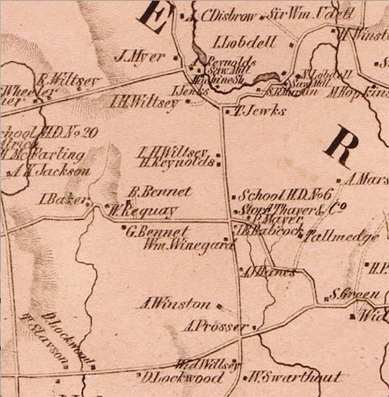
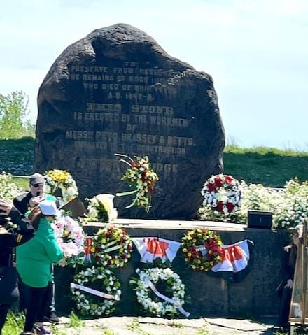
Comparing the map with the family burial plot photographs, I recognize many neighborhood names. For example, of the 54 gravestones, one belongs to the farmer Udell, whose actual given names were Sir William. There were clearly intermarriages and other social bonds represented by those interred on the grounds of Wilsey farm.
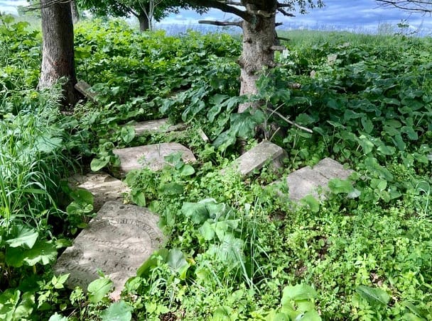
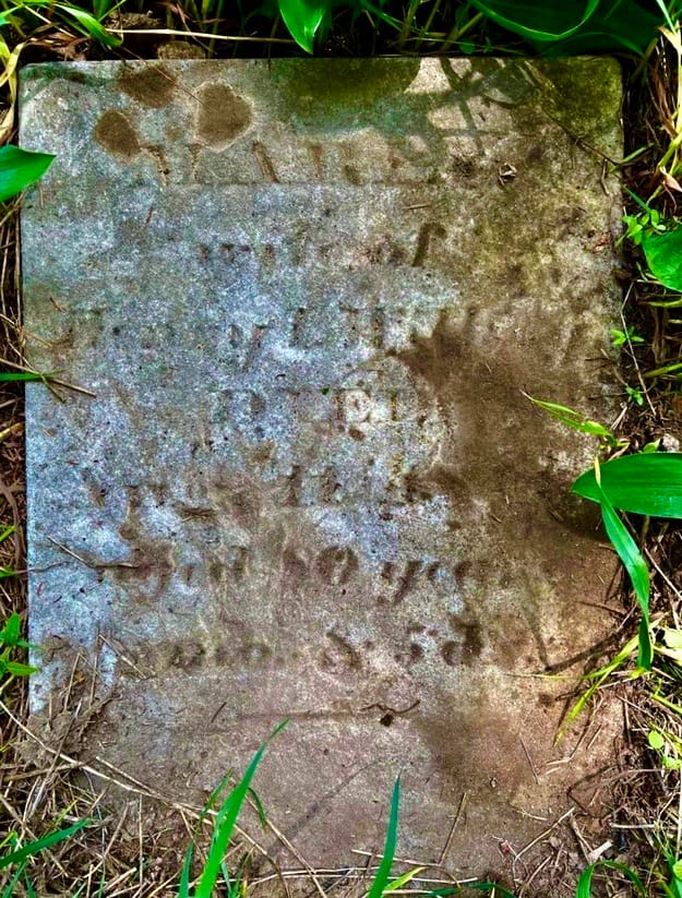
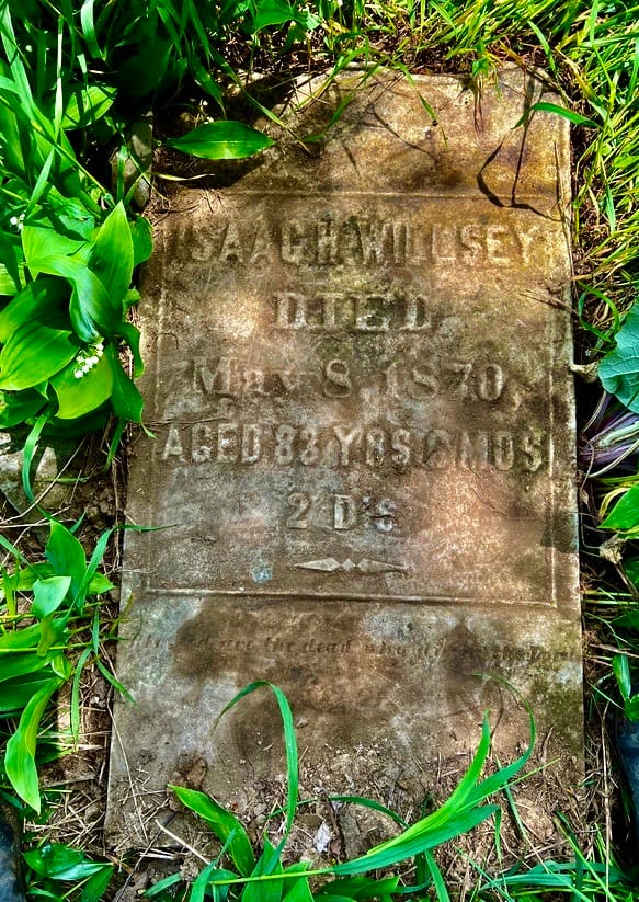
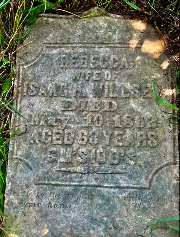
Above left: the current condition of the Willsey burial ground. Above right: Maria Jaycox Willsey, 1766-1848, married to Henry Isaac. She is the great-grandmother of Harriet Wilsey Jennings, who married my great-great-grandfather, the Irish immigrant William Gray. Below left and right: Isaac and Rebecca Willsey, Maria's son and daughter-in-law. (Photos by Gayle Hannay, town historian)
It's intriguing to imagine that, as an octogenarian, Maria might even have dandled great-grand-daughter Harriet on her knee, had her son Eliphalet not headed west in the early 1800s. Eliphalet's daughter Fannie, Harriet's mother, may have been born among her many Westerlo relatives, but other sources suggest it was Auburn, NY.
If so, Fannie (1824-1890) was part of the vast current of white settlers moving into and through western New York at that time. When her daughter Harriet (1844-1913) and her husband William ultimately settled near his brother Worship, it was in rural Weldon, between Champaign and Bloomington, Illinois. They made up part of a cluster of farm families that seems an echo of her Westerlo antecedents. In a 1974 town publication celebrating Weldon, one settler is repeatedly referred to as having been "the first white baby born" in that territory, as though that's something to be proud of. That pride—and those who are being omitted in the wording of that distinction—speaks volumes about whose names matter.
Seeing those family names inscribed on a map, I feel a pleasant new sense of connection to ancestors and to place. However, I do not feel the pride I've heard settler descendants express, about how long their family has lived in this country. I do not feel that, because those lives happened in spaces opened by force. I've written about the particular example of George Washington's scorched earth campaign in New York. Please take a look, if you've never learned about this aspect of the American Revolution:
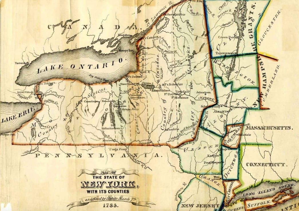
If Fannie was born in Auburn, that places her at the northern tip of Owasco Lake. In what the 1788 map shown at the top of this essay clearly delineates as "Country of the Cayugas."
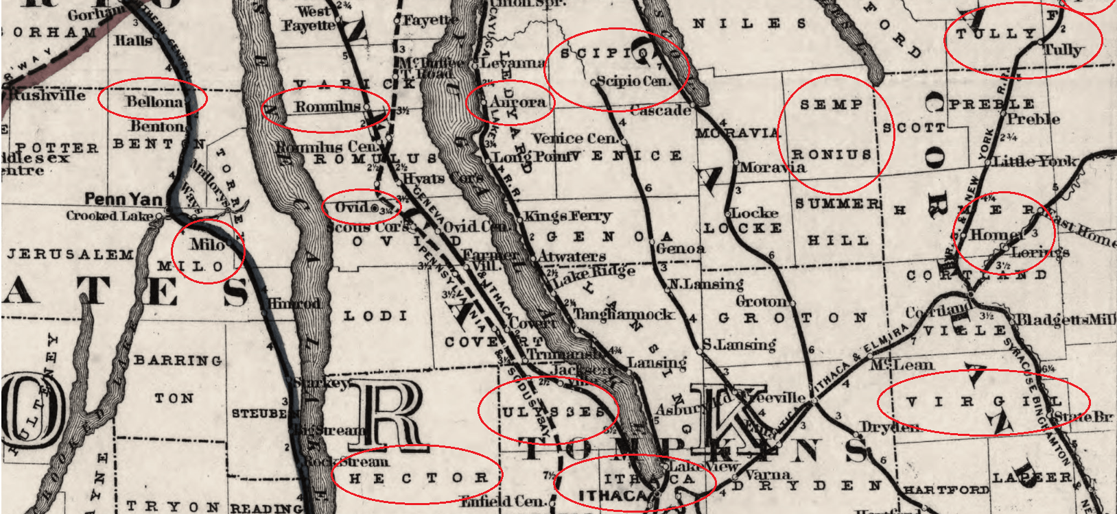
Less than 10 years before that map was made, Generals Sullivan, Van Schaik, and Clinton had burned their way through the fertile farmlands of the Finger Lakes region, the Haudenosaunee homelands. The map below illustrates the process of land dispossession, showing how the government and settlers imposed a layer of claiming and naming on top of those indigenous family, tribal, and place names.
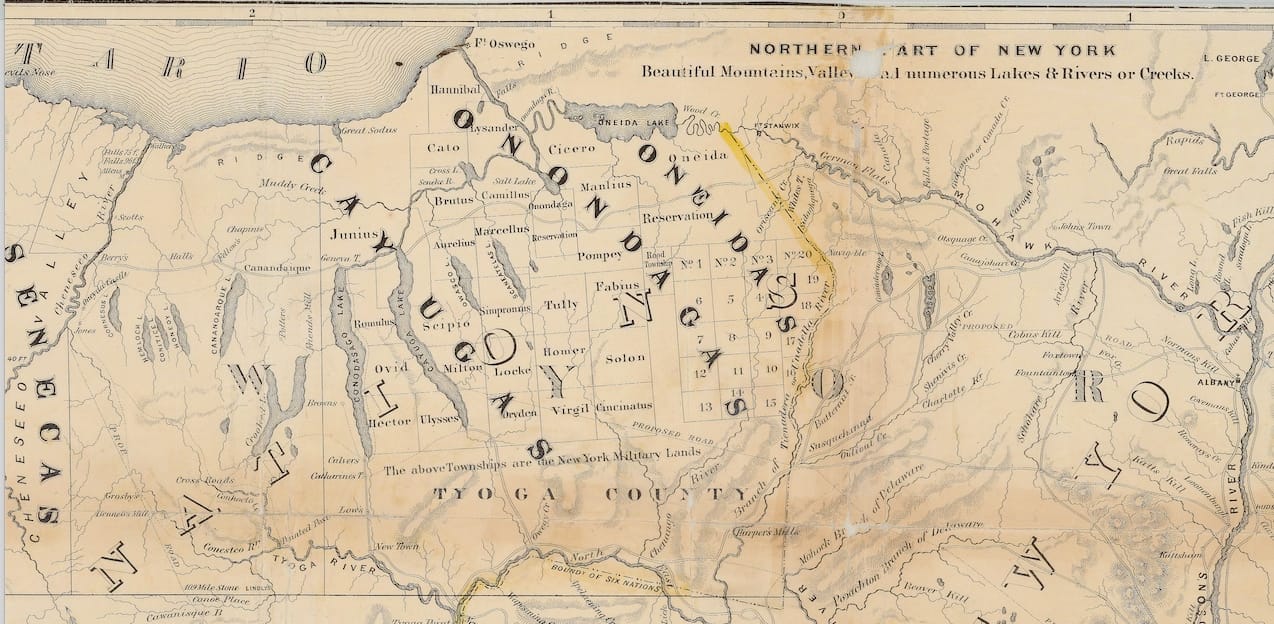
Both maps reflect the fact that Washington converted a huge swathe of this countryside into "bounty" land, promised as a recruitment tool for Revolutionary War soldiers. Unlike the prairie frontier, this part of New York was the frontier of the war. Wrested from the Iroquois in 1779 by the Sullivan expedition, by 1781 these lands were planned as parcels, or "military tracts." After that grid was conceived, according to historian Daniel Koch,
"All that stood in the way was the extinguishment of the Indian title. In 1788, the State of New York signed treaties with factions of the Onondaga and Cayuga Haudenosaunee that turned over several million acres, which were then surveyed and opened for settlement."
I suspect "factions of" is doing a lot of work here, in terms of the validity of these treaties.
If you zoom in on this map, you'll see that Fannie's possible birthplace was in a township called Aurelius, surrounded by Brutus, Marcellus, Fabius, Cicero, Virgil, Homer, and on and on. Check out Koch's full article for more about this classical naming fad in the United States.
While these plots were offered to soldiers from all over New York and New England, many simply sold theirs, sight unseen. Some, though, ended up in the hands of the very soldiers who had admired the fields of corn and pumpkins and orchards full of fruit even while they set them on fire. How must it have felt to them to lay claim to these lands, now stamped with names from Greek and Roman antiquity?
And how readily and rapidly did this newly-imposed map become simply an unquestioned reality for white settlers who came after? I'd like to find out. I'll admit it: I've spent a couple of weekends in the Finger Lakes region. I didn't have a clue about what happened there.
Even some who took the trouble to preserve the history of native languages and names in the region, such as William Beauchamp, did so from a detached, academic standpoint. Reminiscent of Causabon, George Eliot's arrogant, mummified scholar in Middlemarch, Reverend Beauchamp wrote "Aboriginal Place Names of New York" in 1907. Over 300 pages long, it is ordered by county. He name-drops the leading lights in his field, dismisses others as "fantastical" or "dubious" at times, and exhaustively charts debated interpretations. Missionaries are often the ones recording the native place names; they frequently have their own motives.
Beauchamp's tone suggests that he values his work for being an object of study rather than being about people. He quotes a colleague's critique of the language studies of one Reverend Heckewelder, who is found too "credulous," and unreliable because he actually liked the Delawares he lived among. This Mr. Cass condemns Heckewelder's work as "utterly incompatible with that severity of research and exactness of knowledge, which give the investigations into the philosophy of language their principal value."
Beauchamp softens this criticism of his fellow clergyman, but it is clear that he, too, believes that the severity and exactness of knowledge is what it's all about. While impressed to find that numerous water bodies retain Indian names, Beauchamp accepts the common belief in the inevitable disappearance of native languages. He says the multitude of names, "shows how large were the powers of those languages which will soon be classed among those which are dead."
In a strange, chauvinistic introduction, he theorizes about incongruity, bringing in a reference to the military plots:
"It is not necessary to prefer Indian place names to others. They are not always pleasanter in sound, and are rarely poetical, yet we are glad to retain many of them. Some of our very finest names in New York are aboriginal, but names derived from our own ancestry, dear to us from historic or personal associations, full of meaning even to the untrained ear, may be just as good as aboriginal names which mean nothing at all to us, or perhaps any one else. It is just as incongruous to place an Indian prairie name among our mountains as it was to plant the names of Pompey, Cicero and Virgil in central New York. Onondaga is not appropriate on our western plains."
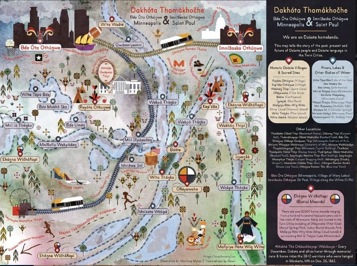
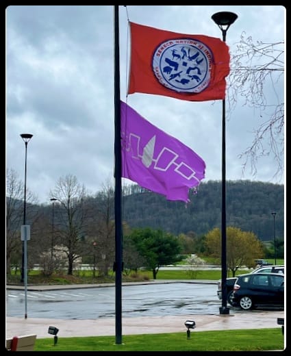
As an alternative to these white settler perspectives, I'd like to give the last word here to a native artist doing important mapping work. Marlena Myles provides a wealth of resources about the history, culture, and language of the Dakota in what is now Minnesota. For example, her map of Minneapolis & Saint Paul demarcates 12,000 burial mounds and other significant cultural sites. Educator Dawi Westerman joins her to offer audio recordings of the pronunciations of the names on the maps.
I hope you'll take a look, and let me know about the maps in your family history.